Geography
At Croxby Primary School we are Geographers!
Intent
We want our children to love geography. We want them to have no limits to what their ambitions are and grow up wanting to be cartographers, town planners, conservationists or weather forecasters.
Our aim is that, through the teaching of Geography at Croxby, we provide a purposeful platform for exploring, appreciating and understanding the world in which we live and how it has evolved. We want to ensure that through Geography, pupils are able to explore the relationship between the Earth and its people through the study of place, space and environment.
In Geography, pupils in our school will learn the skills of understanding locational knowledge; how and where people fit into its overall structure. We also intend for children to become passionate and knowledgeable about our local community and beyond, by learning through experiences in practical and fieldwork activities.
Implementation
A guiding principle of CUSP Geography is that each study draws upon prior learning. High volume and deliberate practice is essential for pupils to remember and retrieve substantive knowledge and use their disciplinary knowledge to explain and articulate what they know. This means pupils make conscious connections and think hard, using what they know.
CUSP Geography is built around the principles of cumulative knowledge focusing on spaces, places, scale, human and physical processes with an emphasis on how content is connected, and relational knowledge acquired. An example of this is the identification of continents, such as Europe, and its relationship to the location of the UK.
CUSP Geography equips pupils to become ‘more expert’ with each study and grow an ever broadening and coherent mental model of the subject.
Key aspects to learning:
Substantive knowledge - this is the subject knowledge and vocabulary used about the world group under four main threads.
![]()
Substantive concepts - are the big ideas, and the golden threads, that run through a coherent and cohesive geography curriculum. They can include place, space, scale, interdependence, physical and human processes, environmental impact, sustainable development, cultural awareness and cultural diversity. Concepts such as change through erosion are taught through explicit vocabulary instruction as well as through the direct content and context of the study.
![]()
Disciplinary knowledge – this is the use of knowledge and how children become a little more expert as a geographer by Thinking Geographically through enquiry-based learning.
Geographical analysis is developed through selecting, organising and integrating knowledge through reasoning and making sense of the content in response to structured questions and well-designed tasks that cause children to think hard as geographers.
*Knowledge notes are an elaboration in the core knowledge found in knowledge organisers. Knowledge notes focus pupils’ working memory to the key question that will be asked at the end of the lesson. It reduces cognitive load and avoids the split-attention effect.
*Retrieval practise is planned into the curriculum through spaced learning and interleaving and as part of considered task design by the class teacher. Teaching and learning resources and provided for class teachers so they can focus their time on subject knowledge and task design.
*Explicit Vocabulary is purposefully sequenced into the CUSP curriculum to ensure Tier 2 and 3 vocabularies are explicitly taught along with the etymology and morphology, relevant idioms and colloquialisms to ensure learning sticks. We aim to provide a high challenge with low threat culture and put no ceiling on any child’s learning, instead providing the right scaffolding for each child for them to achieve.
*Misconceptions are explicitly revealed as non-examples and positioned against known and accurate content as pupils become more expert in their understanding. Misconceptions are challenged carefully and in the context of the substantive and disciplinary knowledge. In CUSP Geography, it is recommended that misconceptions are not introduced too early, as pupils need to construct a mental model in which to position new knowledge.
*Cumulative quiz questions - Feedback, low-threat quizzes, thinking hard tasks and structured assessment tasks all contribute towards the bigger picture of how well pupils retain and remember the content.
Impact
The impact of this curriculum design will lead to outstanding progress over time across key stages relative to a child’s individual starting point and their progression of skills.
HOW DO WE KNOW WHAT CHILDREN HAVE LEARNED?
- Questioning
- Pupil Study (talking about learning with the children)
- Talking to teachers
- Low stakes ‘Drop-in’ observations
- Quizzing and retrieval practise
- Live feedback
Children will therefore be expected to leave Croxby reaching at least age-related expectations for Geography. Our Geography CUSP curriculum will also lead pupils to be enthusiastic geography learners.
What will my child be learning?
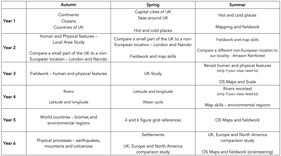
Here is the geography long-term overview.
- Please note that to accommodate the effective implementation of CUSP curriculum this overview may vary for year 23/24 to ensure children have not duplicated topics from our previous curriculum.
EYFS
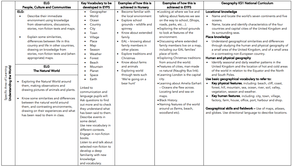
The Early Years Foundation Stage Curriculum supports children’s understanding of geography through the planning and teaching of ‘Understanding the World’. We work in the areas of ‘people, culture and communities’ and ‘the natural world’ where we explore locational and place knowledge, geographical skills and fieldwork, people and communities including different religious and cultural communities and weather and the environmental change.
These aspects are about how children find out about the areas around them and how they are impacted by the changes to the natural environments. Children learn about features of their own environment such as school, home, community and their city through first hand experiences and learn how environments may differ.
We support our geography learning through understanding the different places and environments through stories. Our children enjoy the valuable experiences gained from exploring our school grounds and local walking trips to the nearby residential home.
Our skilled early years practitioners encourage investigation of the environment by giving children time to discuss, comment and ask questions about what they observe about the world around them and are encouraged to be active learners and explore their interests further. We raise questions such as, ‘Tell me about your local area – what will I find there?’, ‘Tell me, what can you see in this photo? What are the buildings like? What is there? What are the people doing?’, ‘How is the country… different from/the same as where we live?’, ‘Tell me about this map. What does it show?’, ‘What special events do you and your family celebrate? How do you celebrate different events?’ ‘What special places do you know? Why are they special?’ and Use the atlas to show me where (character from a story) lives.’
Use of language relating to places, environmental features and communities is used in daily conversations with children for example, ‘community', ‘belief’, ‘atlas’, ‘globe’, ‘explorer’, ‘compare’, ‘local shops’, ‘local playpark’, ‘local church’, ‘carpark’, ‘bridge’ and ‘pollution’. We ensure we are preparing our young geographers by equipping them with the necessary skills to be successful in their future geography learning by developing the disciplinary skills at an early stage.
KEY STAGE 1
The sequence in KS1 focuses young children to develop a sense of place, scale and an understanding of human and physical geographical features.
Later in KS1, CUSP map skills and fieldwork are essential to support children in developing an understanding of how to explain and describe a place, the people who live there, its space and scale.
Initially, children study the orientation of the world through acquiring and making locational sense of the 7 continents and 5 oceans of the world. They extend their knowledge and study the countries and capital cities of the United Kingdom, along with the oceans and seas that surround us, routes and maps can be made concrete in day-to-day experiences in the safety of their school grounds and classrooms.
Throughout KS1, pupils enhance their locational knowledge by studying and identifying human and physical features of places and contrasting locations throughout the world. The location of these areas in the world are deliberately chosen to be culturally diverse.
Fieldwork and map skills are further developed with a study of the local area, using cardinal points of a compass. Maps are introduced through familiar stories as a way to communicate what the place and space is like. Pupils retrieve and apply knowledge about human and physical features in their local context. OS maps are introduced to pupils in KS1 using Digimap for Schools. Simple keys and features are identified and mapped locally to help begin to understand place, distance and scale.
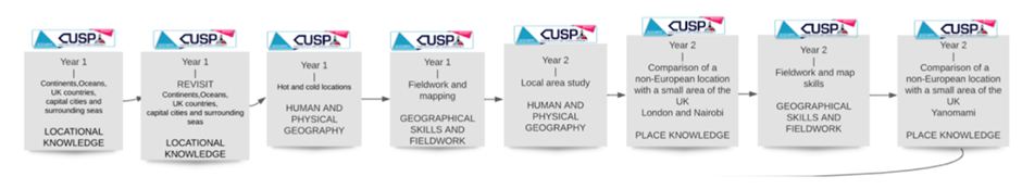
LOWER KEY STAGE 2
As pupils begin KS2, fieldwork and map skills are revisited with the intercardinal points of a compass points being introduced to elaborate on the knowledge pupils already have around cardinal points. This supports a study of the UK, focusing on regions, counties, landmarks and topography. Further studies are undertaken to elaborate fieldwork and map skills through a sharper focus on OS maps.
Pupils elaborate and expand their understanding of human and physical features and apply it to the study of rivers.
To enable accurate location of places around the globe, pupils study absolute positioning or reference systems through latitude and longitude.
Complementing studies on location and position is the focus on the water cycle. It offers explanation and reason about physical processes as well as why certain biomes have specific features in specific global locations. Pupils study geographical patterns across the world using latitude of locations to explain why places are like they are. Further river studies revisit substantive knowledge and these are applied to the River Nile and the Amazon River.
Further fieldwork and map skills are introduced to enrich pupils’ disciplinary knowledge of locations and places.
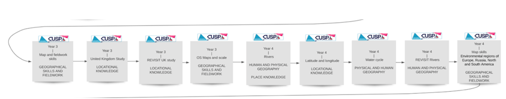
A deliberately planned study focusing on the environmental regions of Europe, Russia, and North and South America draws attention to climate regions.
UPPER KEY STAGE 2
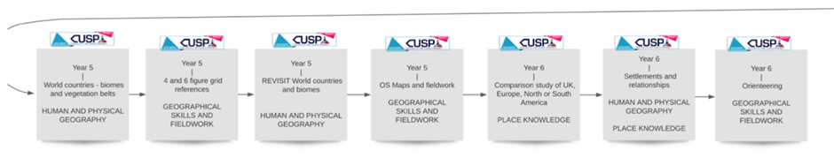
The study of Biomes and Environmental regions builds upon world locations, latitude and longitude studies. World countries and major cities are located, identified and remembered through deliberate and retrieval practice, such as low stakes quizzing and Two things tasks. The study of biomes is revisited deliberately to ensure the content is remembered and applied.
In upper KS2, the study of 4 and 6 figure grid references supports prior learning of reference systems and brings an increased accuracy to mapping and fieldwork skills.
Pupils take part in geographical analysis using patterns and comparison of both human and physical processes as well as the features present in chosen locations. This abstract concept is made concrete through studying and comparing the Lake District, the Tatra mountains of Poland and the Blue mountains of Jamaica. Physical processes such as orogeny and glaciation are acquired to explain significant change over long periods of time. The concept of physical process is revisited through a study of Earthquakes, mountains and volcanoes.
Settlement, trade and economic activities are the focus of a study that draws upon the Windrush generation module in CUSP History. This develops an increasing knowledge about migration and the factors that push people away or draw people towards settlements. Within these studies, pupils make relational connections between settlements and physical or human features.